Category Archives: Marine

Scientists Say There’s Plenty Of Wind Over Oceans To Power Entire Planet


If humans have enough turbines running in the ocean, we could generate enough electricity to power the entire human race, says new research from the National Academy of Sciences

In a paper titled Geophysical potential for wind energy over the open oceans authored by two scientists at the Department of Global Ecology at Carnegie Institution for Science in Standford, California, the researchers provide strong evidence that there is quite a bit of potential for greater downward transport of kinetic energy in the overlying atmosphere. As a result, they write, “wind power generation over some ocean areas can exceed power generation on land by a factor of three or more.”  

Three or more is more than just significant when it comes to searching for renewable energy to replace fossil fuels and nuclear power, both which have had disastrous effects on the environment over the past 100 years, the former contributing to global warming at an alarming rate.

While naysayers might point your attention to the fact that the cost of developing, building and deploying floating turbines is most likely going to be very high, the fact remains that MIT scientists have been working on floating turbines for at least the past 4 years, even floating turbine technology that can produce power when there is no wind.

The downside to these findings is that using all that wind energy means it could drastically alter the climate, since wind has a great effect on how plants and animals live.  But considering the high cost, the researchers say the study really only provides enough evidence for those already in the wind turbine tech arena to expand, rather than replace current energy generation.

The paper makes a comparison of a theoretical floating wind farm consisting of almost 2 million square kilometers and situated in the same amount of space on land in the U.S. versus that of the Atlantic ocean, finding that covering much of the central U.S. with wind farms wouldn’t quite be enough energy to power up both the U.S. and China, some 7 terawatts annually, or seven trillion watts of power.

However, floating turbines in the North Atlantic could theoretically power those two countries and a whole lot more, considering the amount of potential energy that can be extracted over the ocean in the same amount of area.


In our Wi-Fi world, the internet still depends on undersea cables


Recently a New York Times article on Russian submarine activity near undersea communications cables dredged up Cold War politics and generated widespread recognition of the submerged systems we all depend upon.

Not many people realize that undersea cables transport nearly 100% of transoceanic data traffic. These lines are laid on the very bottom of the ocean floor. They’re about as thick as a garden hose and carry the world’s internet, phone calls and even TV transmissions between continents at the speed of light. A single cable can carry tens of terabits of information per second.

While researching my book The Undersea Network, I realized that the cables we all rely on to send everything from email to banking information across the seas remain largely unregulated and undefended. Although they are laid by only a few companies (including the American company SubCom and the French company Alcatel-Lucent) and often funneled along narrow paths, the ocean’s vastness has often provided them protection.

2015 map of 278 in-service and 21 planned undersea cables.
Telegeography

Far from wireless

The fact that we route internet traffic through the ocean – amidst deep sea creatures and hydrothermal vents – runs counter to most people’s imaginings of the internet. Didn’t we develop satellites and Wi-Fi to transmit signals through the air? Haven’t we moved to the cloud? Undersea cable systems sound like a thing of the past.

The reality is that the cloud is actually under the ocean. Even though they might seem behind the times, fiber-optic cables are actually state-of-the-art global communications technologies. Since they use light to encode information and remain unfettered by weather, cables carry data faster and cheaper than satellites. They crisscross the continents too – a message from New York to California also travels by fiber-optic cable. These systems are not going to be replaced by aerial communications anytime soon.

A tangled cable caught by fishermen in New Zealand.

A vulnerable system?

The biggest problem with cable systems is not technological – it’s human. Because they run underground, underwater and between telephone poles, cable systems populate the same spaces we do. As a result, we accidentally break them all the time. Local construction projects dig up terrestrial lines. Boaters drop anchors on cables. And submarines can pinpoint systems under the sea.

Most of the recent media coverage has been dominated by the question of vulnerability. Are global communications networks really at risk of disruption? What would happen if these cables were cut? Do we need to worry about the threat of sabotage from Russian subs or terrorist agents?

The answer to this is not black and white. Any individual cable is always at risk, but likely far more so from boaters and fishermen than any saboteur. Over history, the single largest cause of disruption has been people unintentionally dropping anchors and nets. The International Cable Protection Committee has been working for years to prevent such breaks.

An undersea cable lands in Fiji.
Nicole Starosielski, CC BY-ND

As a result, cables today are covered in steel armor and buried beneath the seafloor at their shore-ends, where the human threat is most concentrated. This provides some level of protection. In the deep sea, the ocean’s inaccessibility largely safeguards cables – they need only to be covered with a thin polyethelene sheath. It’s not that it’s much more difficult to sever cables in the deep ocean, it’s just that the primary forms of interference are less likely to happen. The sea is so big and the cables are so narrow, the probability isn’t that high that you’d run across one.

Sabotage has actually been rare in the history of undersea cables. There are certainly occurrences (though none recently), but these are disproportionately publicized. The World War I German raid of the Fanning Island cable station in the Pacific Ocean gets a lot of attention. And there was speculation about sabotage in the cable disruptions outside Alexandria, Egypt in 2008, which cut 70% of the country’s internet, affecting millions. Yet we hear little about the regular faults that occur, on average, about 200 times each year.

Redundancy provides some protection

The fact is it’s incredibly difficult to monitor these lines. Cable companies have been trying to do so for more than a century, since the first telegraph lines were laid in the 1800s. But the ocean is too vast and the lines simply too long. It would be impossible to stop every vessel that came anywhere near critical communications cables. We’d need to create extremely long, “no-go” zones across the ocean, which itself would profoundly disrupt the economy.

Fewer than 300 cable systems transport almost all transoceanic traffic around the world. And these often run through narrow pressure points where small disruptions can have massive impacts. Since each cable can carry an extraordinary amount of information, it’s not uncommon for an entire country to rely on only a handful of systems. In many places, it would take only a few cable cuts to take out large swathes of the internet. If the right cables were disrupted at the right time, it could disrupt global internet traffic for weeks or even months.

The thing that protects global information traffic is the fact that there’s some redundancy built into the system. Since there is more cable capacity than there is traffic, when there is a break, information is automatically rerouted along other cables. Because there are many systems linking to the United States, and a lot of internet infrastructure is located here, a single cable outage is unlikely to cause any noticeable effect for Americans.

Surfacing.in is an interactive platform developed by Erik Loyer and the author that lets users navigate the transpacific cable network.
CC BY-ND

Any single cable line has been and will continue to be susceptible to disruption. And the only way around this is to build a more diverse system. But as things are, even though individual companies each look out for their own network, there is no economic incentive or supervisory body to ensure the global system as a whole is resilient. If there’s a vulnerability to worry about, this is it.

The Conversation

Nicole Starosielski, Assistant Professor of Media, Culture and Communication, New York University

This article was originally published on The Conversation. Read the original article.

Lake Michigan’s ‘ghost ship’ is now visible from the sky


It may have been the hottest recorded winter in 134 years, but much of the American Northeast endured freezing temperatures early this year, largely owing to a Polar Vortex that pushed seasonal sheets of ice across the Great Lakes in the Midwest. After an early spring, the ice has begun to clear away, and for a brief period, the waters of Lake Michigan are clear enough to see the shipwrecks lying beneath its surface – so large that they are visible from the air.

The U.S. Coast Guard Air Station of Traverse City, Michigan, reported crystal clear water conditions and the sighting of these lost ships while conducting a routine patrol of the area. Last week, a handful of aerial photos were uploaded on their Facebook page. These images were taken of an area near Sleeping Bear Point which is known as the Manitou Passage Underwater Preserve. According to the preserve’s website, this are is “one of the richest areas in Michigan for shipwreck diving.”

The idea of diving for shipwrecks in a lake might seem unusual, but in fact there’s quite a few lost ships buried beneath the lake, some of which date back a few centuries. Local treasure hunters claim to have found a lost ship belonging to 17th century French explorer Robert LaSalle, but have yet to verify if the ship they videotaped is in fact four centuries old. The season is somewhat short lived, as warmer weather leads to algal blooms, which will again make the water difficult to see through.

So why do so many appear around the Manitou Passage – an area lying just north of the North and South Manitou Islands, both of which act as a type of barrier that protect ships in the area from potential storms. The growing lumber trade in the Great Lakes region by the mid-19th century turned the Manitou Passage into an important waterway, and that’s about the time that one of the newly sighted ships dates back to.

Susan Cosier, who writes for the journal On Earth, has reported on the latest finds:

“Not much is known about most of the wrecks, but they do include one doomed vessel, the James McBride, which was thought to be the first to carry cargo from the Atlantic Ocean to Lake Michigan in 1848. Facebook commenters helped fill in some of the blanks, but most the historic details are still, well, watery.”

The Coast Guard Air Station has tacked on any information people were able to accumulate either from common knowledge or off of the Internet in the captions for each of the images. Out of the five sighted ships that they posted pictures of, there are still three that remain unidentified.

Bill Chappell, a reporter from NPR.Org has noted that sighting these wrecks from in the air is a “fairly common” occurrence, as he was told by one of the patrolling pilots, Lieutenant Commander Charlie Wilson, but this is an unusual case, because typically the number of wrecks is generally “not in the numbers we saw on that flight.” Chappell also interviewed workers at the Michigan Department of Environmental Quality who noted: “An estimated 6,000 vessels were lost on the Great Lakes with approximately 1,500 of these ships located in Michigan waters.”

Other wrecks so far investigated within the Manitou Passage include the more modern vessel The Francisco Morazan, which was an ocean-going freighter hurtled aground during one particularly rough snowstorm on November 29, 1960. The Morazan actually shipwrecked directly on top of another ship over half a century older: a wooden steamer called the Walter L. Frost, which disappeared on November 4, 1903. Both of these wrecks took place in shallow water, only a few hundred yards away from the shore, according to the preserve’s website.

Agricultural runoff near the area causes algal blooms that become more prevalent with warmer temperatures. Therefore, these particularly views are rare, as the lake will soon be covered over. The vessel pictured is the Rising Sun, which sank on October 29, 1917, after all 32 passengers on board were successfully rescued.

James Sullivan
James Sullivan is the assistant editor of Brain World Magazine and a contributor to Truth Is Cool and OMNI Reboot. He can usually be found on TVTropes or RationalWiki when not exploiting life and science stories for another blog article.

The Big Extinction Event You Never Heard About


The entire early history of the Earth itself is one of extreme violence – a series of extreme catastrophic accidents that ultimately shaped it into the habitable form it is today – collisions, volcanoes, earthquakes. Even when the Earth was a habitable place, thriving with life, it was unsafe from mass extinction events, which took place roughly every 50 million years or so. To date, scientists describe a “big five” list of these incredible events, the last one wiping out the last of the non-avian dinosaurs 65 million years ago. While it is sometimes argued that the rapid disappearance of species in the present day is the sixth major extinction event, there actually may have already been one that was considerably overlooked in our distant past.

Today, paleontologists argue that this sixth major extinction event took place 260 million years ago, towards the end of a geological age known as the Capitanian, which predated the major Permian-Triassic extinction event by only about eight million years. A recent study offers up the evidence that there was a massive die-off during this age in the shallow, cool waters near what currently make up modern day Norway. This new discovery, along with the combined earlier evidence of extinctions taking place in tropical waters, suggests that the Capitanian event was a catastrophe of global magnitude.

“It’s the first time we can say this is a true global extinction,” said David Bond, a paleontologist from the University of Hull in the United Kingdom. Bond recently led an international team in a study that has been published online this week through the Geological Society of America Bulletin. As overlooked as it has been, Bond maintains that in its magnitude, this Capitanian event was actually on par with the dinosaur-killing extinction that took place 65 million years ago. “I’d put this up there with it, albeit with slightly less attractive victims,” Bond says.

Not a whole lot of people are aware that the dinosaurs existed in a number of forms, over three different eras (the Triassic, Jurassic, and Cretaceous) with some minor extinction events in between, let alone the Capitanian era. Actual scientific interest in this age first began during the early 1990s, during which paleontologists discovered the evidence for fossil extinctions happening in rock formations across China. These rocks had originally formed on the floor of what was once a shallow tropical sea. Most foraminifera — which are tiny, shelled protozoans, only slightly larger than bacteria — had died out, alongside numerous species of the clamlike brachiopods, which make up some of the most commonly found fossils – shell impressions that can be found near most modern streams.

There is also evidence of a potential trigger to blame for the gradual chain of destruction: a series of ancient volcanic outbursts in China. Afterwards, these volcanoes would congeal into a rock formation known as the Emeishan Traps in southwest China’s Sichuan Province. The hot flowing basalt would give off massive amounts of sulfur and carbon dioxide, which was released into the air, potentially leading to a sudden global chill. The brief cooling period would then be followed by a substantially longer period of global warming. The release of carbon dioxide would have also led to intensified ocean acidification, along with oxygen depletion in the water. Ocean acidification later played a role in the Permian-Triassic event, which only took about 60,000 years to obliterate most species on Earth, and was by far the most deadly that the Earth has ever experienced. Many scientists suspect that a similar massive burst of volcanic activity as the one in Emeishan Falls took place in Siberia, setting off a chain reaction of events that would wipe out over 90 percent of life on Earth.

So why has the Capitanian extinction so overlooked? Little is known, and many have suggested that it was a regional event, or that it may have in fact been just an isolated disaster, a symptom of the trends that would eventually culminate in the much larger Permian extinction. It was only officially recognized as an individual era within the Permian Age in 2001 on the international timescale used by geologists. The newly discovered evidence may dispel some of these reservations about the era. One such piece of the puzzle comes out of Spitsbergen, which is the largest island of the Svalbard archipelago, just off the coast of Norway in the Arctic Ocean. It is there that Bond and his colleagues did an examination of chert rocks. These rocks are the result of silica buildup, a volcanic byproduct which has been produced out of the skeletons from dead sponges. The chert may also contain several species of extinct brachiopods. At the time of the Capitanian event, these rocks would have begun forming within tens of meters of cooler water at midlatitudes. But here it’s not so much what the rocks contain that’s interesting, as what isn’t there. There was a point recorded the rock record when these fossils suddenly disappeared.

“They all drop out,” says study co-author Paul Wignall, who is a paleontologist at the University of Leeds in the United Kingdom. “It’s like a blackout zone and there’s nothing around.” At some point a little further along in the rock record, several of the brachiopod species recovered, according to Wignall. Afterwards, the mollusks begin to take over in sizable numbers, thriving right up until the devastation of the Permian extinction begins, another eight million years after. Right now, the ocean acidification due to anthropogenic climate change is reducing pH levels in the ocean water, affecting numerous species that have evolved at specific pH levels and bleaching coral reefs, a pattern that will disrupt a number of marine ecosystems across the planet. Perhaps 260 million years ago, the situation was not too different. There’s been some even more unsettling news – the discovery of shellfish cooked by the increasing acidity, as the ocean tries to act as a carbon sink, absorbing the record levels of carbon dioxide released into the air.

The research team has actually had a difficult time attributing the latest record to the same moment documented by fossil records throughout China. Isotopic dating systems are too uncertain to provide the researchers with a helpful absolute date. Another standard method of dating – biostratigraphy, which links the timing between the different rock layers by the nature of the fossils they contain. In this instance, it’s the appearance and disappearance of fossilized teeth from small tiny eel-like creatures known as conodonts. However, these also couldn’t be used, because the population had diverged, and different species lived in cool waters from those living in tropical waters. Instead, the team has had to rely on a pattern of similar swings at the levels of different isotopes, something that occurs in both parts of the world where the evidence was found, implying that both Scandinavia and Asia had both experienced alterations in oceanic chemistry around the same time.

The imprecise dating may actually be a part of the problem, according to Matthew Clapham, who works as a paleontologist at the University of California, Santa Cruz. He did not participate in the study but thinks that the events dated by the study team may have actually taken place a bit more recently — happening only about 255 million years ago. “They’ve definitely identified a real event, which is really interesting,” he agrees. “Their age model is less convincing.” He also put their discovery in perspective of some recent work in China, which suggests that the full extent of the Capitanian extinction and its effect on different species may actually tell the opposite story – suggesting that it was not nearly as bad as many paleontologists had originally thought. When it comes to listing extinctions, Clapham thinks that the Capitanian is probably 30th or 40th on the hierarchy but certainly not the sixth. Rather, the new discoveries may have been a symptom of the impending Permian mass extinction.

Bond, however, remains convinced that perhaps one day science books will list the Capitanian as one of the worst extinction events in history. “You have to change a lot of people’s minds,” he said. Right now, he is studying the fossil records of Russia and Greenland that may further support his case that the Capitanian was a global disaster. Clapham, too, would like to see a greater understanding of what was largely an enigmatic stretch in the history of our planet. “It’s a very mysterious event—it’s an interesting thing to study,” he says.

James Sullivan
James Sullivan is the assistant editor of Brain World Magazine and a contributor to Truth Is Cool and OMNI Reboot. He can usually be found on TVTropes or RationalWiki when not exploiting life and science stories for another blog article.

Will California Ever Recover From The Drought?


On Monday, March 2, 2015, Stanford scientists published a paper in the journal Proceedings of the National Academy of Sciences detailing the findings of their study on climate change and the role it plays in California’s drought. The main finding from the study was that human caused climate changes are actually increasing California’s chances of drought. These man-made causes are also increasing the risk that the drought will become a permanent problem for California’s future.

To reach these conclusions Stanford scientists looked at data in regards to greenhouse gases and the kind of effect they have on California. To get the best overall picture scientists looked at data past and present data, they even went a step further and looked at future data. Now what this data has shown is a warming trend across the entire state. According to Noah Difenbaugh, a climate scientist at Stanford this warming trend “probably would not have happened without humans.”

So knowing that greenhouse gases are causing the warming trend across the state is one thing, but what is going to happen because of it. So, what happens to California if global warming continues? According to Difenbaugh, “more frequent occurrences of high temperatures and low precipitation that will lead to increased severe drought conditions.”

This bad news comes the day before the third manual snow survey in the Sierras. Nobody expects the news from the survey to be very good, especially if you consider that according to the data from other electronic readings water content is only at 195 when compared to the average for the date. To make matters worse weather agencies are reporting that the 2015 winter has been the warmest winter on record for several Bay Area cities. In fact, many of these cities have broken several records for highest temperatures. Average temperatures in San Francisco this winter were 57 degrees, up just less than 2 degrees from the previous record of 55.70 during the winter of 1970.

So far, the winter of 2014-2015 has seen the lowest amount of precipitation in a calendar, as well as record breaking high temperatures. But, despite how bad things might seem the Department of Water Resources will raise the State Water Project allocation to 20%, which is 5% more than last year. And, the reason this is happening is because of the storms in December and February. So, what does all of this mean for California and will the state ever be able to reach 100% again? That is something that these Stanford scientists set out to discover.

The last time California water levels reached 100% was back in 2006. And, while the scientists cannot solve the problem of the drought becoming a permanent problem for the state they do believe that what they discovered can help plan for the future.

Older studies theorize that the reason for the current drought in California is the high-pressure system that remains stalled over the Pacific Ocean. The high-pressure system being stalled over the ocean is what is causing the storms to be pushed away from California, which increases the risk of a drought. The studies also found an increased risk of stalling high-pressure systems when greenhouse gas concentrations were present. The new study went a step further and delved into 120-year-old data that was just recently released. What they discovered was that the number of droughts nearly doubled in frequency. During 1896-1994, California saw only 14 droughts, but through 1995-2014 California saw 6. During 1896-1994 drought conditions, which is where you have low precipitation and warm temperatures occurred only about a ¼ of the time. Now thanks to climate change warm weather is happening most of the time, so warm and dry conditions occurring in the same year is becoming more common. And, it is the warm temperatures that are causing the extreme drought conditions, as the warm weather causes snow t melt faster, but also dries out the soil. The drier the soil the less snow run off there is to fill the reservoirs.

Now these Stanford scientists cannot predict the future, but they can create simulations they can use to predict what is going to happen next. What they see happening is the warmer weather trend continuing, increasing the chances of warm and dry years, which will increase the number of droughts California will see.

New Jersey Coast Sees Extreme Event


In normal everyday life four inches often doesn’t seem to be that much. Most people cut 4 inches off of their hair without giving it a second thought. So, how would you react if you heard that the ocean along the Atlantic Coastline has rose 4 inches in the past year.

Some of you might not think too much about it because after all when you look at how vast the ocean is, four inches really doesn’t seem to be that big of a deal. Many people are under the impressions that the water levels in the ocean are going to rise and fall. And, it is true that sea levels rise and fall over the course of the years, but it is how quickly they rise that is a concern.

This week a study was published that showed just how quickly the sea levels rose along the east coast. During 2009 to 2010, the eastern coast saw a four-inch rise in sea levels. Yes, you read that right the sea rose four inches in just two years, which is almost unheard of. According to geosciences doctoral candidate Paul Goddard the rise in sea levels along the east coast is an “extreme sea level rise.” Goddard also happens to be the lead author on the paper dealing with the sea level rise that was recently published in the ‘Nature Communications’ journal. To give people an idea of how rare this event really is a statistical analysis was performed. What this analysis showed was that it was a 1 in every 850 year event. And, according t Goddard “unprecedented during the past century.

”When looking at the rise in sea levels along the east coast measurements were taken from gauges along the entire coast. What the measurements show is that from as far north as Newfoundland and all the way down to New York the ocean rose four inches. Once the measurements reached Cape May, it only showed a three-inch rise in levels, which is still pretty high. In following the coast line scientists discovered a rise in levels as far south as Cape Hatteras, N.C.

Now what makes this event so noteworthy is not just the four-inch rise, but also the fact that it happened in 2 years. Sea levels raise a small amount each year and normally to reach a four-inch rise you are looking at a time period of about 30 years. The good news though is that what is causing the sea levels to rise so rapidly is not permanent. So, while the sea levels did go up, they will eventually start to go back down.

So, while four inches may not seem that much to you and your friends when you are talking about the everyday aspect of life. When it comes to ocean levels rising four inches is quite a big deal. And, when it happens in two years, it causes everybody to stop and take notice.

Is There Life Beneath the Tiger Stripes of Enceladus?


While most people recognize Saturn from its nine immense rings, you’ve probably never heard of Enceladus, one of its lesser moons that hasn’t received nearly as much attention in the media lately as Titan. While researchers have proposed that life may exist on Titan, even non-carbon based life forms much different from any life as we know it on Earth, Enceladus is another likely candidate for maintaining lifeforms. It might even be a bit more inviting than Titan, where any submersible probes would have to be built to endure extreme cold. Although Enceladus contains an immense sea encrusted with ice, two recent studies have suggested that hydrothermal vents exist beneath it, allowing heat to enter and maintain life forms similar to those found on Earth. It’s an idea similar to what planetary scientists think may be happening on Jupiter’s nearby moon, Europa.

As interest in the search for extraterrestrial lifeforms has increased, and perhaps Enceladus may be among the first places to look.

“You have a habitat that could possibly harbor life,” said Linda Spilker, project scientist for NASA’s Cassini mission to Saturn in an interview with NBC News. “So it’d be very interesting to go back with a future mission to make the measurements to could tell you whether or not there might be life in Enceladus’ ocean.”

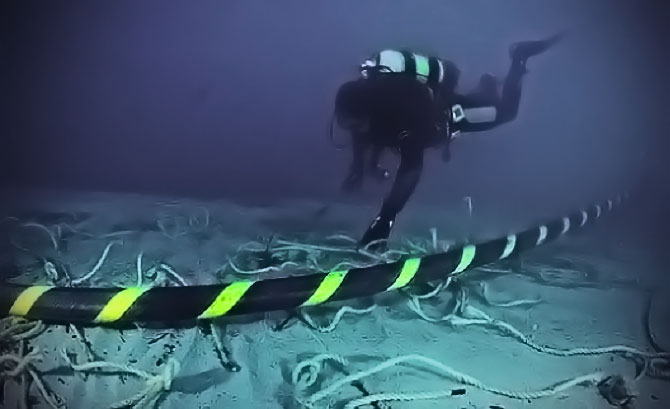
Hydrothermal vents are like the geysers of the ocean, present along mid ocean ridges, forming when underwater mountains like the Mid Atlantic Ridge shift in position. Ancient hydrothermal vents exist on Mars, where an ocean that was once larger than the Arctic Sea has been discovered. However, planetary scientists have yet to see any hydrothermal vents on Enceladus at work, much less any direct evidence of marine life. Enceladus’ warm water is concealed underneath an icy crust that’s 25 miles deep. However, the researchers believe that volcanic activity would be the best way to explain materials captured on the moon’s surface by the Cassini spacecraft.

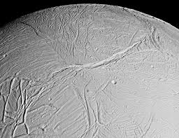
Almost ten years ago, the Cassini researchers documented what appeared to be geysers of ice water leaping from the surface of Enceladus — evidence that there’s a liquid reservoir beneath the sheets of ice. In the following years, scientists made an in-depth analysis which determined that this ice encrusted sea happens to lie in a region adjacent to the moon’s south pole. Water emanates out of cracks within the ice known as “tiger stripes.”

Scientists also learned that the icy spray was partially responsible for Saturn’s faint E-ring. Using a Cosmic Dust Analyzer they looked closely at the contents of the spray. Along with naturally formed ice crystals, they discovered particles rich in silicon, about one nanometer in size – bits of dust made of silica, the same compound known for plugging up volcanoes on Earth. Along with the methane, this is a prominent sign of volcanic activity from hydrothermal vents. It is also likely that these mechanisms could support underwater life, just as silica and methane do in deep-sea settings on Earth.

“What we did first was just to know what these particles were, and by doing this, we started to think about how they formed,” said Hsiang-Wen Hsu, a researcher at the University of Colorado’s Laboratory for Atmospheric and Space Physics.

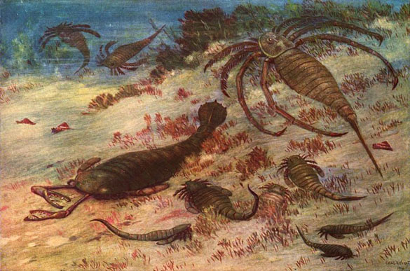
In order to replicate similar particles, the scientists learned the only way to make them from ordinary rocks was to have minerals interacting with alkaline water under temperature that were at least 194 degrees Fahrenheit. The water also had to contain salinity levels just under four percent. All of these conditions can be found in the hydrothermal vents beneath the Atlantic Ocean, a region called the Lost City, in which volcanically heated water permits the existence of some strange marine life, capable of thriving without sunlight. “That is a very good analog to what we have,” Hsu said.

The study, which was led by Hsu, was published in the journal Nature this week. An additional study has just been accepted for publication in Geophysical Research Letters, and gives further evidence to the hydrothermal hypothesis.

Alexis Bouquet of the Southwest Research Institute conducted the second study – giving an analysis of Enceladus’ water plumes. Gases in the plumes are consistent with Earth’s subglacial lakes, with higher levels of methane in the plumes than what was predicted.

It is possible that methane is escaping from Enceladus’ ice, but researchers have another explanation: Hydrothermal vents may be “compensating by adding methane into the ocean.”

Spilker, who works for NASA’s Jet Propulsion Laboratory, said that the methane study is a “nice, complementary part of the story.” While researchers had known of water rising out of the cracks in Enceladus’ ice, they weren’t sure if it was warm enough to sustain life.

“What’s really striking is that this is the first time we’ve seen active hydrothermal vents outside of the seafloor on Earth,” Spilker said.

This vent activity may be stimulated by a tidal pull from Saturn and its other moons, particularly Dione.

So far, Enceladus has been known to contain the “Big Three” criterion for life on Earth: the presence of liquid water, chemical building blocks essential to organic activity, and even energy sustenance in the form of hydrothermal heat. So is there life on Enceladus?

“That is the big question left to be answered,” said Hsu.

It is still possible to explain the observations made by Cassini through other means. “It is necessary to have a more systematic study to understand why this way works and the others do not,” Hsu said.

Even if Enceladus does contain these hydrothermal vents, they may not be active long enough to allow life to evolve. “For life, the conditions have to be stable for a long time. It’s most likely that the activity on Enceladus is episodic,” Hsu said.

Cassini will sample the moon’s water plumes again in October when it makes a close flyby — but it was not equipped to detect life. It will be some time before another expedition is made to Enceladus, as researchers are currently at work on an expedition to Europa, whose ocean is thought to be much larger than the one on Enceladus.

James Sullivan
James Sullivan is the assistant editor of Brain World Magazine and a contributor to Truth Is Cool and OMNI Reboot. He can usually be found on TVTropes or RationalWiki when not exploiting life and science stories for another blog article.

Scientists Re-create 170-year-old Beer


Back in 2010, some archaeologists investigating a 19th century Baltic Sea shipwreck found something more unusual than treasure in the ship’s cargo – four beer bottles fully intact, with the brew still sealed inside. The amber ale was likely brewed in Belgium back in the 1840s, and was on its way to ports in Scandinavia.

You might wonder how well it held up, but surprisingly not too badly for being nearly two centuries old. “These bacteria were still alive,” said Brian Gibson, a senior scientist from the VTT Technical Research Centre in Espoo, Finland, not far from where the bottles were discovered. While beer has been around for at least 7,000 years, being brewed by the ancient Mesopotamians in Iraq, and many breweries have worked to recreate beers from the Middle Ages and American colonial era, Gibson believes this batch is likely the oldest bottle of beer in the world that’s still intact.

Gibson and his colleagues from the University of Munich did an in-depth chemical and microbiological analysis of the beer recently, publishing their work this week in the Journal of Agriculture and Food Chemistry. Despite the inevitable contamination from salt water, they were able to learn quite a bit about the processes of mid-19th century brewing.

“We have a reasonably good idea about what kind of hops were used, different ones than today,” said Gibson. “These hops would have been harsher, these days they are quite mild. The one surprising thing is the beers were quite mild. The original alcohol level was 4.5 percent, nothing extreme.”

Shortly after their retrieval from under the sea, the discovery was celebrated with a monumental beer tasting, consisting of beer experts throughout Finland who came to sample the 170-year-old brew. Rather than using a novelty talking bottle opener, they inserted a thin needle through the cork, taking their samples from two different bottles, in order to avoid exposing the contents to open air. However, the taste testing ended up being something of a disappointment in the end. The researchers described the ancient beer’s scent fairly vividly in their paper, as a cross between “autolyzed yeast, dimethyl sulfide, Bakelite, burnt rubber, over-ripe cheese, and goat with phenolic and sulfery notes.” During its time under the sea, water leaked through the cork of the bottle, rendering the contents about 30 percent salt water.

Despite how good it looked, the beer was considerably degraded. Like modern beers, this beer had a shelf life – a sell by date that had long since come and gone. Aside from the taste of sea water, the tasters had another issue. According to Gibson: “For the analysis, it was difficult to pick out the original flavors. We invited some of the most experienced beer tasters in Finland. The flavors were from bacterial contamination and not the original flavors of the beer.”

Therefore, Gibson and his team had to rely on a further chemical analysis to be taken on the sugars that remained, as well as the alcoholic compounds in order to get a better idea of how the beer was made – their primary interest being the practice of pre-Industrial distilleries.

“We looked at esters, which give beer a fruity or flowery taste. Most of the compounds that we would expect were there. In terms of the fruitiness, probably similar to modern beers. High level of 2-phenyl ethanol which gives a rose or floral aroma.”

In comparison to modern day craft brews, Gibson said their batch was similar to an amber or lambic style ale, which are normally brewed with wild hops. One of the beers had a fairly pronounced hops flavor, while the other likely had more of a fruit flavor, similar to modern summer beers. In many ways, the ingredients in the beers were fairly similar to modern ones, although it was likely that 19th century beer was much more sour, as they did not have a way of keeping acid-producing bacteria from the brew during fermentation.

Sam Calagione, who is the founder and president of Dogfish Head brewery in Milton, Del., has already shown great intrigue in their finds, as his company has worked to recreate historic beers since 1998 with recipes obtained from archaeological digs.

Dogfish’s “Midas Touch,” named for the fabled Greek king, was based on a jar found in a 2,700-year-old tomb uncovered in Turkey, a Bronze Age drink made from barley, saffron and white muscat grapes.

“The whole idea of looking backward for creative inspiration and culinary adventure is really catching on,” Calagione said. “All (the scientists) can give us is a laundry list of ingredients. It is up to us to come up with a creative recipe. What the alcohol content is, whether it’s filtered or carbonated. We have a lot of creative input in bringing these creative beers back to life.”

Stallhagen Brewery of the Aaland Islands in Finland has recently imitated the Baltic Sea beer, under the label “1843.” In addition to the beer bottles, the divers also found 150 bottles of champagne in the wreckage.

James Sullivan
James Sullivan is the assistant editor of Brain World Magazine and a contributor to Truth Is Cool and OMNI Reboot. He can usually be found on TVTropes or RationalWiki when not exploiting life and science stories for another blog article.

Lake Michigan Wind Makes Sand Sculptures


Joshua Nowicki, a Michigan photographer, and his wife had a rather unexpected surprise this Valentine’s Day weekend when they planned a stroll along the shores of Lake Michigan. Blasts of arctic wind and snow forced them to postpone their walk until the next day, but in the end, the conditions actually proved somewhat favorable – for reasons he captured pretty well with his camera.

“On Valentines Day my wife and I had been intending to go out dinner but due to the blizzard condition that day, we decided to post-pone our evening out until Sunday,” he said to News 10 of Detroit.

“My wife is extremely supportive of my photography career and encourage me to go out and take some photos of the lake and lighthouse.”

When they finally did go for their walk along the frozen sand, the landscape was rather different than he had anticipated.

“I was expecting that with the high winds there might be some wave crashing over the pier giving the lighthouses a new coating of ice. However, the lake ice had extended past the lighthouses (therefore no crashing waves on the pier) so I was unable to take the photos I was hoping to take.”

Instead of the traditional shots of a beach and lighthouse landscape at dusk that Nowicki had originally hoped for, he saw something else – what appeared to be intricately constructed mounds jutting out of the frozen sand all along the beach – what appeared to be the lost remains of a forgotten civilization. Nowicki momentarily felt like the farmers who first discovered the hidden remains of Pompeii centuries after it was covered by ash. Overnight, carefully constructed monuments appeared to be rising out of the sand.

“As I walked home along the beach I saw some of the small sand structures. The first ones I saw were very small however a little farther along the beach I saw more and larger ones. The largest were about 12 inches tall. At Silver Beach County Park in St. Joseph, Michigan I saw five areas with the sand structures. The largest area that one patch covered was about 3 feet by 10 feet.”

The extreme temperatures – which are also responsible for covering 94 percent of Lake Michigan with ice – something that made for some stunning pictures last year in the wake of the Polar Vortex – had caused the sand to freeze. Extreme winds coming off the lake during the blizzard pushed water ashore, and the frozen sand began to erode much like rocks, only slower, and leaving a smoother shape when it took chunks of sand back into the water. You might think of the process as similar to how vast prehistoric rivers gradually gave way to forming canyons, only the erosion process takes a few hours rather than the work of centuries. The phenomenon is hardly unknown, and not even one that was unfamiliar to Nowicki:

“I had seen some similar but smaller ones at the beach a couple of years ago. At that time I had just taken up photography and was not able to take decent photos of them. It was about 6:30pm on the 14th when I took some of the photos. As it was getting dark, I decided to come back at sunrise on the 15th to take more photos. By the 15th they had further eroded but some were still there. By the 16th the sun (even though it was still cold) had mostly dried them out and they had fallen down into little piles of sand.”

This time he came prepared, however, careful to add a little perspective to each. Although many of the wind sculptures were relatively small, some of the pictures appear to be from the surface of an alien world, where Nowicki has managed to crawl into one of their strange dwellings:

“Being that they were relatively small (12 inches or less) I decided to lay down on the sand to take the photos. I really wanted to show the detail of the formations.”

The tower formations are similar to the Hoodoo columns found along the Colorado Plateau in Utah, which formed due to erosion from the glaciers melting after the last Ice Age.

Josh’s beach photos have become not only an internet sensation, but were even featured on Good Morning America as well as The Weather Channel, AccuWeather, Colossal, the Detroit Free Press and the Huffington Post. They can be viewed here at his blog: http://joshuanowicki.smugmug.com/New-Photos/

James Sullivan
James Sullivan is the assistant editor of Brain World Magazine and a contributor to Truth Is Cool and OMNI Reboot. He can usually be found on TVTropes or RationalWiki when not exploiting life and science stories for another blog article.