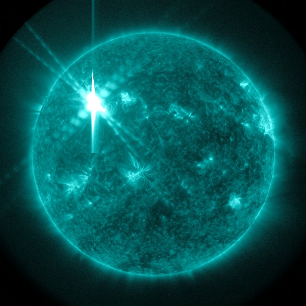
Earth experienced a geomagnetic storm Monday because of a coronal mass ejection (CME) and mid-level solar flare, according to NASA. The CME, which originated at 10:24 p.m. EDT on Saturday, exploded from the sun at about 780 miles per second, and touched Earth at 1:59 p.m. EDT on Monday, the space agency said Wednesday. The National… Continue reading →
WASHINGTON, June 16, 2015 /PRNewswire-USNewswire/ — NASA and the United Nations Office for Outer Space Affairs (UNOOSA) have launched a global photography competition to highlight how the vantage point of space helps us better understand our home planet, improve lives, and safeguard our future by aiding sustainable development on Earth. To highlight the role of space-based… Continue reading →
WASHINGTON, June 12, 2015 /PRNewswire-USNewswire/ — NASA and university scientists will discuss at 2 p.m. EDT, Tuesday June 16, astrobiology research activities and technology that are advancing the search for evidence of habitability in our solar system and beyond. The briefing will air live on NASA Television and the agency’s website. Briefing topics will include the… Continue reading →
In a significant discovery, glass has been found on Mars, throwing up the possibility of past life on the Red Planet. The breakthrough was attained by Nasas Mars Reconnaissance Orbiter which detected deposits of glass within impact craters on Mars. “Though formed in the searing heat of a violent impact, such deposits might provide a delicate… Continue reading →
Anxiety is mounting as biblical theorists predict the end of the world will occur between 22 – 28 September 2015. The most vociferous of the preachers predicting the collective demise is self-proclaimed Prophet Rev Efrain Rodriguez, who claims to have written to NASA in 2010 warning of the asteroid. The letter to NASA said to have… Continue reading →
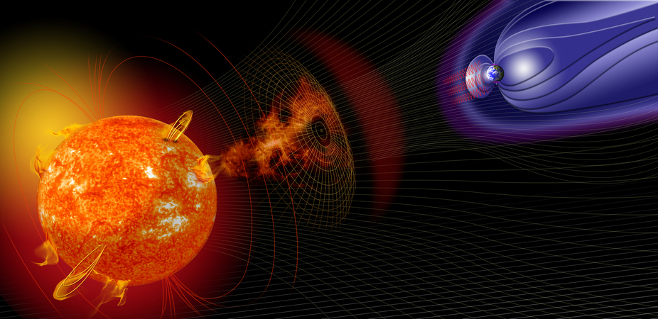
Solar storms start their lives as violent explosions from the sun’s surface. They’re made up of energetic charged particles wrapped in a complex magnetic cloud. As they erupt from the sun’s surface, they can shoot out into interplanetary space at speeds of up to 3,000 kilometers per second (that’s 6.7 million miles per hour). Depending on their direction of travel, these energetic storms can journey past Earth and other planets.
If a solar storm makes it to Earth, it can disrupt a variety of modern technologies including GPS and high-frequency communications, and even power grids on the ground, causing radio blackouts and citywide loss of power. It can also wreak havoc within the aviation industry by disrupting communication methods.
To combat related potential economic losses, affected industries have been seeking a solution that can provide them with at least 24 hours of warning. With enough lead time, they can safely change their operational procedures. For example, passenger planes can be rerouted or power grid transformers can begin the slow process of “winding down,” all of which require at least a day’s notice – a huge jump beyond the 60-minute advance warning currently common. By building on earlier research, my colleagues and I have come up with a technique we think can meet that 24-hour warning goal.
A false alarm issued on January 7 2014 about an unusually large coronal mass ejection underscored the scope of the forecast problem.
Magnetic fields dictate solar storm severity
The strength with which a storm can affect our everyday technological infrastructure depends largely on the orientation of its magnetic field. Often the magnetic field within a solar storm has a helical structure, twisted like a corkscrew. But, much like tornadoes on Earth, these solar storms undergo significant changes during their evolution – in this case, as they leave the sun and travel toward the planets.
NASA’s Magnetospheric Multiscale mission investigates magnetic reconnection.
With a specific field orientation, the floodgates open, allowing the solar particles to enter the otherwise protective bubble of Earth’s atmosphere (the magnetosphere). This interaction between the solar material and Earth’s magnetosphere is predominately driven by a process of joining each other’s magnetic fields together. This interaction is called magnetic reconnection.
North and south attract and combine. Geek3, CC BY-SA
This realignment of the field works in a similar way as two bar magnets attracting. If similar poles of each magnet (north and north) are brought together, the field lines repel each other. Unlike poles attract and combine together. If the poles are unlike, in our case between the solar storm and the Earth’s magnetosphere, they become magnetically connected. This new connectivity of the Earth’s magnetosphere now contains the trapped energetic particles that were previously isolated in the solar storm. If a large penetration of energetic particles makes it into the Earth’s upper atmosphere, the reaction provides the visual extravaganza that’s often called the Northern Lights.
To date, predicting the magnetic field structure within solar storms hitting Earth has remained elusive. Modern forecasting centers around the world, such as at NOAA and UK Met Office, are dependent on direct measurements from inside the solar storm by a spacecraft just in front of Earth (for example, the newly launched Discvr satellite by NOAA). Measurements tell us the direction of a solar storm’s magnetic field and thus whether it’s liable to reconnect with the Earth’s magnetosphere in a dangerous way for our technology. We’ve been stuck with less than 60 minutes of advance warning.
The difficulties in creating a reliable forecast have centered around our inability to reliably estimate the initial structure of the storm above the sun’s surface, and the difficulty in observing how storms evolve as they spend about two days traveling to Earth.
My colleagues and I recently published an article in Space Weather that proposes an improved method for predicting the initial magnetic structure of a solar storm. Getting a better handle on the origin of these solar storms is a substantial step toward predicting how the storm can affect us on Earth, and to what extent.
Our method relies on correctly modifying a previous discovery about how the motions of solar plasma (of mostly hydrogen ions) and magnetic field hidden below the sun’s surface can affect the initial structure of a solar storm. It’s called the solar dynamo process. This is a physical process that is believed to generate the sun’s magnetic field. It’s the engine and energy source driving all observed solar activity – that includes sunspots and long-term solar variability as well as solar storms.
Exploded view of a solar storm flaring out from the sun.
We think combining this modified initial storm model with a new method that incorporates a storm’s early evolutionary stages will lead to significant improvements to our forecasting predictions. Triangulating the entire solar storm by using cameras at three locations from NASA’s STEREO and SOHO spacecraft in interplanetary space, using modern modeling techniques we’ve developed, enables a more robust prediction system. Since these cameras are located at very different vantage points in space, we can use them in conjunction to improve our estimations of the total shape and location of the solar storm – much like the depth of field we achieve by seeing the world through two eyes.
Predictions matching reality
So far, we’ve tested this new predictive technique on eight different solar storms, with the first forecasts showing significant agreement with the real data. Further advanced statistical testing with a larger number of storms is now under way within NASA Goddard’s Community Coordinated Modeling Center.
A burst of solar material erupts out into space. Where’s it headed? NASA/Goddard/SDO, CC BY
“We’ll test the model against a variety of historical events,” said Antti Pulkkinen, director of Space Weather Research Center at NASA Goddard and a coauthor of the publication. “We’ll also see how well it works on any event we witness over the next year. In the end, we’ll be able to provide concrete information about how reliable a prediction tool it is.”
Building our own copy of Mars in the laboratory was hard work. We had to shift 15 tonnes of sand to create a swimming-pool-sized model of the red planet. But the effort was well worth it as our experiments shed light on a much-debated issue: the origin of ancient water on the planet. The model suggests water erupted from large subsurface lakes creating enormous volcano-like eruptions.
Back in the 19th century Giovanni Schiaparelli peered through his telescope and spied networks of channels on the planet. The similarity to the watercourses on Earth is striking. Ever since this discovery, scientists suspected that Mars could have had liquid water on its surface.
Historical map of Mars based on Giovanni Schiaparelli’s observations. wikimedia
Now, it is widely accepted that Mars did have surface water once upon a time. But all the contents of those channels have long since gone. Mars’ atmosphere is now very thin (about 1% of that on Earth), which means that any exposed water essentially boils off into space. The tiny fraction that remains on modern Mars is locked away as either ice at the poles or within abundant water-rich materials, such as clay. So we can’t observe any ongoing water erosion on the red planet’s surface.
Shovel ready
I normally work on the formation of rivers and channels on our own planet. But the Martian versions are no less fascinating and it turns out that all the tools that I use to study Earth-bound rivers are pretty good for extraterrestrial ones as well.
Groundwater eruption in an experiment (left) and the resulting landscape of such event on Mars (right). Author provided
Unfortunately there are a couple of major problems with studying channels on Mars. First, and most obvious, I can’t go there yet (and I don’t think my wife would let me go even if I could). Second, there really isn’t much water on Mars any more. So to answer the question of how water channels on Mars formed, it was obvious what we had to do. We had to build Mars here. Or at least a model of it.
It is tough being a scientist.
So a team of international scientists and I grabbed our shovels and set about constructing a mock-up scaled version of the red planets surface. After shifting all the sand we had our model of Mars’ sediments housed in a chamber the size of a swimming pool all within our Total Environment Simulator.
We used the model to add water in a variety of ways. We let it rain on our model, we trickled and flooded water over our mock Martian surface and we forced water up from beneath. Then we compared the features on the Martian surface with those that we made in our simulator. The scaled experiments, that took us three months to complete, suggest that the most important water flows on ancient Mars came from massive outburst floods of pressurised groundwater.
Topography map of Kasei Valles on Mars from NASA in Google Earth. NASA, CC BY-SA
We think the water may have erupted from large subsurface lakes creating vast volcano-like eruptions with maximum flood volumes that could be over 10,000 times bigger than the Amazon River on Earth. Our results suggest that this groundwater repeatedly flowed up to the surface, albeit very sporadically and in ever-decreasing volumes over time, carving out the channels that provide us with the evidence of these mega-floods from the past.
It is quite possible that our experiments now explain the formation of these channels that caught the eye of Giovanni Schiaparelli as he peered through his 19th century telescope. Perhaps most importantly they suggest that water was not around for very long on the surface of Mars, which makes the hunt for extra-terrestrial life that bit more complicated. If water was not around in liquid form for very long then the chances that life existed on mars diminish significantly.
Daniel Parsons is Prof. of Process Sedimentology and Associate Dean for Reserach (Science and Engineering) at University of Hull.
A new study has revealed that cosmic radiation sustained during journeys into deep space could cause subtle brain damage in astronauts, decreasing their ability to think, remember and react. The study, which comes while NASA is working on a manned mission to Mars, was published in the journal Science Advances on Friday. The researchers found that… Continue reading →
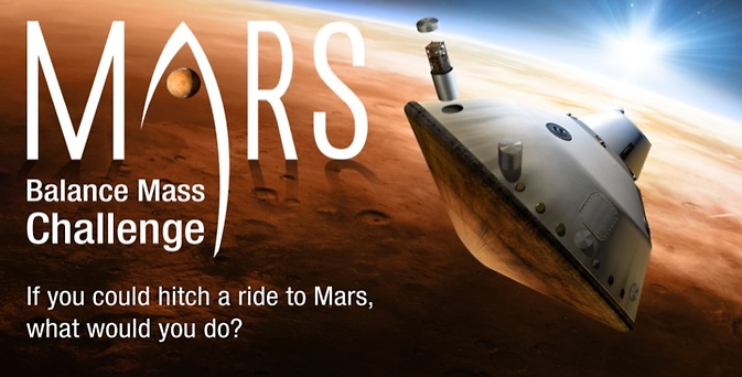
HOUSTON, April 29, 2015 /PRNewswire-USNewswire/ — A self-employed technical consultant from Texas with an idea to study the Martian atmosphere and a team of engineers from Michigan with a way to study Martian weather are the winners of NASA’s Mars Balance Mass Challenge. Ted Ground of Rising Star, Texas, was awarded $20,000 for his idea to… Continue reading →
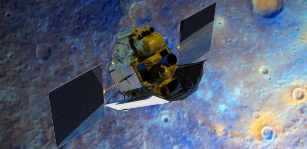
More than a decade after it left Earth, the space probe MESSENGER is in the dying days of its exploration of the planet Mercury.
The spacecraft is about to run out of fuel, and after a planned final manoeuvre on April 30, it will plummet into the surface of Mercury out of view of watchers on Earth but will remain in contact until 10 to 15 minutes prior to its demise.
Mercury is the smallest of the eight current solar system planets and the one nearest to our star. (Pluto was relegated to being a mere dwarf planet in 2006.)
Unlike the other well studied and photographed planets, Mercury has until recent times remained mostly unexplored.
The planet – just 57.9 million km from the sun – was first visited by NASA’s Mariner 10 probe which undertook three flybys of Mercury between March 1974 and March 1975.
A photo-mosaic of images collected by Mariner 10 as it flew past Mercury showing the planet’s southern hemisphere. NASA
Today you can even study its craters and other surface features using the Google Earth interface.
The MESSENGER spacecraft
MESSENGER was launched on August 3, 2004, weighing 507.9kg, 1.42m tall, 1.85m wide, and 1.27m deep. It is powered by two body-mounted gallium arsenide solar panels and a nickel-hydrogen battery.
The probe carries a number of science instruments to map the surface of the planet and its magnetic field, detect atmospheric gases and various elements of Mercury’s crust, and much more.
After its launch, the spacecraft flew by Earth once (in 2005), Venus twice (in 2006 and 2007) and Mercury three times (twice in 2008 and once in 2009).
This multi-flyby process greatly reduced the amount of fuel needed to decelerate, although at the cost of increasing both travel time and distance.
Planets such as Venus and Mars have atmospheres that enable the minimisation of fuel by utilising atmospheric friction to enter orbit.
But Mercury’s atmosphere is far too thin for such manoeuvres. Using gravity assist manoeuvres at Earth, Venus and Mercury provided the necessary reduction in velocity enabling it to use its rocket engine when entering its elliptical orbit around Mercury.
Interplanetary trajectory of the MESSENGER orbiter. NASA
The insertion into a highly elliptical orbit minimised the amount of fuel necessary and allowed time for the probe to cool down after passing between the planet and the sun.
It also allowed measurement of the effects of solar wind and Mercury’s magnetic field at varying distances, as well as capturing close-up measurements and photographs of the surface and exosphere.
After travelling 7.9 billion km and orbiting the sun 15 times MESSENGER entered Mercury’s orbit on March 18, 2011. The science instruments were reactivated on March 24 and the first photo from orbit was returned to Earth a few days later on March 29.
By the numbers: MESSENGER’s ten years in space (2014). NASA
Discoveries and science
The MESSENGER flybys of Mercury in 2008 and 2009 were able to confirm the earlier Mariner 10 results that Mercury had an internal magnetic field and also to show that its magnetic dipole – which is just like a large bar magnet – is aligned to within 5° of the planet’s spin axis.
In an early flyby in 2008 there was a totally unexpected discovery that there were large amounts of water present in Mercury’s thin atmosphere. Visual evidence of past volcanic activity on the surface of Mercury and evidence for a liquid iron planetary core added to the incredible discoveries.
in November 2012, NASA announced, evidence of water ice and carbon-containing tar-like organic compounds molecules at both of Mercury’s poles. In these areas the deepest parts of the craters are always in shadow with temperatures reaching as low as -200C.
This discovery lends weight to the idea that Mercury, like the Earth, was bombarded by water-laden comets and mineral rich asteroids during the early years of the solar system.
Kandinsky crater lies near Mercury’s north pole, and may have hosted water ice. MESSENGER spacecraft’s Wide Angle Camera broadband image appears at left, outlined in yellow, and superimposed on an MDIS polar mosaic. The view on the right shows the same image but with the brightness and contrast adjusted to show details of the crater’s shadowed floor. NASA/Johns Hopkins University Applied Physics Laboratory/Carnegie Institution of Washington
Mission extended
The original mission was initially for a year and then extended to allow for observations of the predicted 2012 solar maximum.
The solar maximum is the period during the normal 11 year solar-cycle where the number of sunspots, solar flares and Coronal Mass Ejections are the highest. These are the major indicators of solar activity and MESSENGER was in a prime position to get information about the effects of increased solar activity.
In November 2013, Messenger was one of a number of spacecraft used to observe and photograph both Comet Encke (2P/Encke) and Comet ISON (C/2012 S1).
A second extended mission was scheduled to last through to March this year and has taken advantage of the probe’s orbital decay to obtain highly detailed close-up photographs of ice-filled craters and other landforms at Mercury’s north pole.
And so after a mission lasting almost 11 years the tiny robotic probe MESSENGER will end its mission on 30 April by crashing into the surface of the planet. Even then data will be gathered: the new man made crater the probe crash makes will hopefully provide new information for the NASA scientists. On its final orbit the probe will be only around 250 – 500 m above the surface at around 14,500km/hr.
NASA scientists will continue to gather data from MESSENGER until it finally succumbs to Mercury’s gravity.
A question of ethics?
This raises a question: just as comet and asteroid impactors may have delivered organic matter to their targets, what possible contaminants will this human-made visitor introduce?
Since 1958, with the increasing potential of discovering extraterrestrial life, there have been groups of scientists such as Committee on Space Research (COSPAR) examining the foundational ethical principles involved in the exploration of space.
In 2010, a workshop was convened to consider whether planetary protection measures and practices should be extended to protect planetary environments within an ethical framework that goes beyond “science protection”.
Previous planetary protection policy had been aimed at avoiding the contamination of planetary environments by biological contaminants or terrestrial microbes that could compromise current or future scientific investigations, particularly those searching for indigenous life.
Spacecraft have been crashed into a number of planets as well as our moon. So as we continue to send probes to the very edge of our solar system, perhaps we are seeding these worlds with the basic volatile elements that could in a distant future lead to the evolution of more advanced life forming.
Or perhaps as early settlers to foreign shores on Earth introduced diseases with devastating consequences, what effect could any nasty little hitchhikers have on the destiny of whatever life may already exist.
Mercury – so much known yet so much to learn!
We now have detailed high-resolution maps of Mercury created from the hundreds of thousands of images taken by MESSENGER.
The globe on the left was created from the MDIS monochrome surface morphology base map campaign. The globe on the right was produced from the MDIS colour base map campaign. Each map is composed of thousands of images, and the colour view was created by using three of the eight colour filters acquired. Credits: NASA/Johns Hopkins University Applied Physics Laboratory/Carnegie Institution of Washington
The launch of the European Space Agency’s BepiColombo planned mission to Mercury is planned to take place during a one-month long window from January 27, 2017.
This is a joint mission with the Japan Aerospace Exploration Agency (JAXA) and should enter Mercury orbit in January 2024 carrying two separate orbiters, the Mercury Planetary Orbiter (MPO) operated by ESA and the JAXA designed Mercury Magnetospheric Orbiter (MMO) carried by the Mercury Transfer Module (MTM).
One of its tasks will be to observe the 16m crater made by MESSENGER when it impacts at around 3.9 km/s (about 14,040 km/h). Scientists will be monitoring this fresh crater in order to identify the process of space weathering—the erosive effect of radiation and tiny meteorite strikes—in action.


